International Journal of Marine Science, 2017, Vol.7, No.2, 8-18
12
Coastal sand barrier spits close to river mouth are often extremely dynamic, which involves transport of sediments
in both the long shore and cross-shore wave directions with rapid migration rates (Simeoni et al., 2007; Dan et al.,
2009; 2011). The investigation of the spit formed in Rosetta Estuary revealed that its formation is a result from the
coastal currents induced by waves that carry the coastal sediments to inside the estuary.
Considering the Rosetta Estuary sand spit shape and position evolution, three major scenarios can be recognized.
(I) Spit encroaching the inlet mouth seaward before establishment of Aswan High Dam and between 1986 and
1993 (Frihy and Lawrence, 2004; Kaiser, 2014). (II) No spit formation, just after undertaken the dredging of the
spit. (III) Spit forming towards river side after the construction of Aswan High Dam and as consequences of the
limitation of of water discharge.
2.2 Factors affecting the formation of the spit inside the Rosetta Estuary
Different human intervention like building of dams, dredging in river mouth and deforestation in the upstream
side often decrease or increase the amount of sediments reaching the coastal zone (Stanica et al., 2007; Nagarajan
et al., 2015). After the sediment budget of the spit inside the Rosetta Estuary is the human interference by
construction of Aswan High Dam and the hydraulic control structures. The factors affecting the formation of
Rosetta spit can be summarized as the following.
2.2.1 Reduction in water discharge to Mediterranean Sea through Rosetta Estuary
Limitation of water discharge from River Nile is one of the main source that enhanced accumulation of sediments
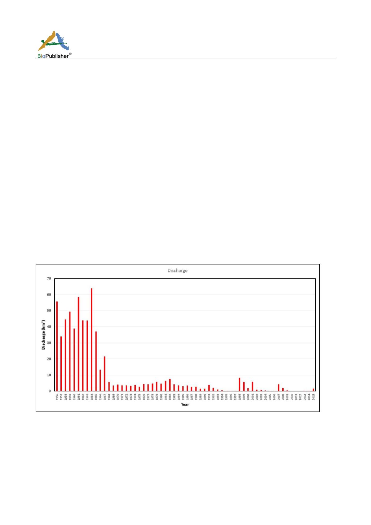
to form spits originated from the coastal area. Figure 5 shows the annual discharge of Nile River water from
Edfina barrage through Rosetta Estuary during the period 1956-2015. The original source of these data is from the
General Authority of Irrigation from Delta Barrages of the recent values from 2008 to 2015 and the rest values are
reported by Said and Radwan (2009).
Figure 5 Yearly Nile River discharge (km
3
) through Rosetta Branch during the period 1956-2015
Before the construction of the Aswan High Dam, Nile River discharged to the Mediterranean 62 km
3
during
1912-1942 (Gerges, 1976) and 46.93 km
3
during 1956-1965 through its branches. After 1966 with the
establishment of the High Dam the discharge to the sea remarkably decreased to be 3.92 km
3
during 42 years
(1966-2007) through Rosetta estuary (Said and Radwan, 2009).
2.2.2 Change in salinity distribution
Temporal increase of the salinity values was found in Rosetta Estuary. During 1986-1987 the salinity range in
Rosetta Estuary was 0.2-11.0 ppt with average 4.06 ppt (Samaan et al., 1996) and increased to 2.8-38.3 ppt with


