Basic HTML Version


International Journal of Marine Science 2014, Vol.4, No.43, 1-9
http://ijms.biopublisher.ca
3
landforms be predicted, but also past and present
processes can be interpreted (Pethick, 1984).
An analysis of sediments sampled from both the
shore and offshore helps the researchers to
understand movements and coastal evolution, to
interpret past processes and also to find the linkage
between sediment characteristics and beach shapes.
The southern Caspian Sea coast has not previously
been explored in detail. This paper presents new data
from field surveys that demonstrate a direct
correlation between beach profiles and sediment size
on this coast.
2 Methods
This study is part of a comprehensive research
project examining the behaviour of the southern
Caspian Sea coast in response to its changing water
level. The research was conducted based on the
information obtained from three field surveys. To
investigate the correlation between the beach
morphology and sediment characteristics on the
Iranian Coast of the Caspian Sea, the literature and
background of the subject was reviewed including
morphological, hydrographic and topographic maps
on the scale of 1/100000. These maps were provided
by the Iranian Caspian Sea National Research
Centre, Iran's National Cartographic Centre, the
Geological Survey of Iran and the Iranian National
Institute for Oceanography respectively.
The first field survey was undertaken in order to
understand the study area. Appropriate information
was gathered in every region where access to the
coast was possible. The information was
documented by a hand GPS, filming and picturing
and as an important part, interviews with coastal
residents were performed throughout the survey. For
instance, fishermen had a working knowledge of
sandy bars on the nearshore bottom; therefore,
practical information was obtained from them.
The northern part of Iran is divided into three
provinces; Guilan, Mazandaran and Golestan. Most
of the stations selected in this research are
introduced by the names of the cities in which they
are situated (Figure 2). The first survey began in
Astara and finished in Gomishan. It covered almost
all of the 700 km length of the southern coast of the
Caspian Sea. After this survey, the stations of the
second survey were chosen. During the second
survey, information for the whole coastline
consisting of sediment characteristics and beach
profiles was gathered. Stations were selected at
locations that were representative of the general
situation thereabouts. In Figure 3, the locations of 24
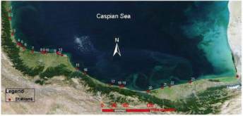
stations are shown.
Figure 3 Twenty-four stations selected during the second
survey.
Notes: 1: Astara; 2: Landvil; 3: Talesh; 4: Parrehsar(1); 5:
Parrehsar(2); 6: Kapourchal; 7: Anzali (Bashman); 8:
Golshan(1); 9: Golshan(2); 10: Golshan(3); 11: Kiashahr(1);
12: Kiashahr(2); 13: Kiashahr (3); 14: Dastak; 15: Kelachay;
16: Ramsar; 17: Nashtarood; 18: Chalus; 19: Noshahr; 20:
Noor; 21: Mahmood Abad; 22: Babolsar; 23: Larim; 24:
Gorganrood
During the second survey, foreshore profiles were
mapped, beach sediments were sampled and
observations of shore features were documented.
Furthermore, more information was collected by
personal communications with southern Caspian Sea
coast residents.
Sediments were sampled along profiles at backshore
and surf zone locations in each station. In addition,
cross-shore profiles were surveyed within a distance
of 150~300 m from the shoreline, dependent on
shore slope and landforms. Also, the nearshore
profile up to a depth of 1.5m was mapped by wading.
Information about deep sediments and overall slope
of the seabed was obtained later during the third
survey.
After reviewing previous data and studies conducted
by Iran's Caspian Sea National Research Centre and
the Iranian National Institute for Oceanography,
eight principal sampling stations were chosen for