Basic HTML Version


International Journal of Marine Science 2014, Vol.4, No.43, 1-9
http://ijms.biopublisher.ca
2
and anthropogenic factors (Shiklomanov et al.,
1995), rejecting the geological and tectonic effects
(for example Rychagov, 1997; Golitsyn, 1995).
Moreover, historical repeated water level oscillations
in the Caspian Sea have been interpreted from
sedimentary deposits (Hoogendoorn et al., 2005;
Kroonenberg et al., 1997; Kroonenberg et al., 2007;
Mamedov, 1997; Rychagov, 1997). Present coasts of
the Caspian Sea were formed in response to its
repetitive level variations during the New Caspian
transgression which began 8,000 years B.P. These
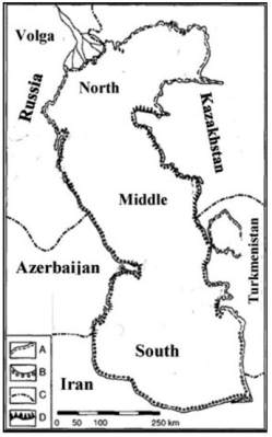
coasts can be classified into four categories (Kaplin
and Selivanov, 1995): mud flats; depositional coasts
composed of bars, spits, etc.; erosional coasts; and
deltaic coasts (Figure 1). Mud flats generally were
formed in the lowlands and rivers create deltaic
coasts. Also, depositional coasts mark the areas in
which mountain ranges are close to the sea. The
Caspian Sea possesses, approximately, all of the
different coastal types which can be found along the
world’s coastlines. The causes and formation of
these coasts have been addressed in scientific
publications for instance: the barrier coast of
Kaspiisk in Russia at the western Caspian Sea coast
was comprehensively studied by Kroonenberg et al.
(2000); Kroonenberg et al. (1997) investigated a
gently sloping coast of the Volga delta; and the
present day Kura delta, composed of sandy and
clayey bodies was considered by Hoogendroon et al.
(2005). For the southern Caspian Sea coast, however,
published data are in relatively short supply (Kazanci
et al., 2004).
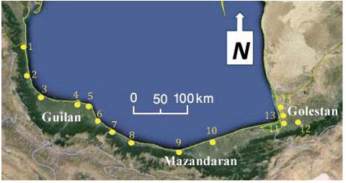
Almost 700 km of the southern Caspian Sea coast is
sited inside the Iranian border (Figure 2).
The southern coast of the Caspian Sea can be
morphologically categorized into five zones.
Nearshore slope, shore morphology and sediment
characteristics vary along the southern Caspian Sea
coastline (Khoshravan, 2007). In the east, where the
coast is composed of fine grain sediments, waves are
prevented from reaching the shore due to the gentle
slope of the nearshore zone. Sandy beaches stretch
along the hundreds of kilometres of the southern
Caspian Sea coastline and coarse grained beaches
can be observed in some segments. These coasts
were affected by the Caspian Sea level change in
accordance with their offshore and onshore slopes.
Different behaviours observed on different segments
of the southern Caspian Sea coast are due to the
differences between offshore and shore gradients
(Lahijani et al., 2007).
Figure 1 The Caspian Sea, bordering countries, sub-basins,
coastal morphological types (left hand figure).
Notes: A: mud flats; B: depositional coasts; C: deltaic coasts;
D: erosional coasts (after Kaplin and Selivanov, 1995).
Figure 2 Three of Iran’s provinces bordering the Caspian Sea.
Notes: 1: Astara; 2: Talesh 3: Anzali; 4: Kiashahr; 5: Dastak;
6: Kelachay; 7: Ramsar; 8: Nashtarood; 9: Noor; 10:
Babolsar; 11: Bandar Torkaman 12: Gorgan; 13: Gorganrood;
14: Gomishan
Coastal sediments are a linkage between the energy
source, waves and coastal landforms. There is no
landform if sediments are not created and moved.
Present day coastal sediments are composed of the
materials resulting from cliff erosion, riverine
sediments and sea bed erosion. By analysing these
sediments not only can the development of coastal