Basic HTML Version


International Journal of Marine Science 2014, Vol.4, No.43, 1-9
http://ijms.biopublisher.ca
4
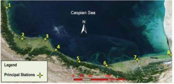
this survey (Figure 4). In each station, sediments
were sampled by divers along profiles at right angles
to the coast at five depths (2, 4, 6, 8 and 10 m).
Hydrographic profiles were surveyed by sounding
up to a depth of 10 m. Particle size distributions of
the samples were determined in accordance with
ASTM C136
2014). The median diameter,
d
50
, is frequently used to define a sand sample and
can be directly measured from the grading curve.
Finally, beach profiles provided shore slopes, beach
face slopes and nearshore slopes.
Figure 4 Principal stations.
Notes: 1: Astara; 2: Anzali; 3: Dastak; 4: Kelachay; 5:
Nashtarood; 6: Noor; 7: Babolsar; 8: Gorganrood
3 Results and Discussion
The North Alborz thrusting fault plays an important
role in shaping the present morphological form of
the southern Caspian Sea coast. This fault
determines the border between the Alborz Mountain
Range and coastal areas and strongly affects the
width of the coast in different segments. Also, the
rivers feeding the Caspian Sea from the south
contribute great amounts of sediment to the shores to
expand their width. Only two morphological
phenomena in the east and west of this coast can be
seen distinctly from the rest: Gorgan Bay in the east
and Anzali lagoon in the west. In the rest of the
regions, simple morphology such as mountains,
gentle or steep foothills, small or relatively big
lagoons, sandy dunes and sand bars at the shore or
nearshore can be observed. The existence of each of
these morphological phenomena in a region is
dependent on the conditions of that region; for
example, the steeper the nearshore bed slope is, the
more sandy bars are formed on the nearshore
(Kaplin and Selivanov, 1995).
Shore sediments and nearshore sediments vary along
the southern Caspian Sea coast based on their type,
and where the overall width of the coast reduces, the
sediments are coarser. The distance of the mountain
ranges from the sea in different areas of the coastline
determines the width of the shore. At some points,
the shore width is very narrow, nearly 1 km (for
example western Mazandaran, around Ramsar),
while in some other places such as the eastern parts
it exceeds 60 km.
Shore slope varies from place to place. Both the
offshore slope and the nearshore slope are being
changed along the coast and these two slopes are
substantially different in most regions. In some parts,
the beach face slope is different from the general
beach face slope observed along these coasts, that is,
the coarser the sediments around the shoreline, the
steeper the beach face slope. There is a correlation
between shore slope, nearshore slope and sediment
grain size. In some regions great rivers (for example
the Sefid-Rud in central Guilan) which flow into the
Caspian Sea expand the shore width. More than 50
rivers flow into the Caspian Sea from the south, the
sediments of which have affected the morphology of
the shore and influence the spatial distribution of the
sediments characteristic. Waves, wave induced
currents and riverine processes have a significant
effect on coastal morphology. The southern Caspian
Sea coast is mostly dominated by spilling breakers
especially in Central Guilan, West Mazandaran, and
East Mazandaran. In Golestan the closure depth
point is far from the shore, as is the wave breaking
point, due to the low beach gradient. As a result, the
waves are prevented from approaching the shoreline
and do not have a significant impact on the coasts.
In West Guilan, the nearshore zone is steeper than
that of Golestan and waves lose a portion of their
energy before reaching the shore, while waves are
breaking close to the shore in the other segments of
the southern Caspian Sea coastline as a result of the
steep gradient of the nearshore zone.
Sea level and sediment supply are two main factors
controlling the highly variable river mouth and delta
configurations (Lahijani et al., 2008). The Caspian
Sea had considerable fluctuations in its level. The
level of the sea has changed by around 3 m during
the 20
th
century. This phenomenon and its impacts