Basic HTML Version


International Journal of Marine Science 2014, Vol.4, No.65, 1-7
http://ijms.biopublisher.ca
2
growth ranges between 18 to 36 °C, however optimal
growth are at an average water temperature of 26 to 28
o
C annually (Birkeland, 1997). While (Nybakken,
1982) states the optimal growth temperature for coral
is 23 to 25
o
C. Tolerance limit of coral growth in some
places reaching 36 to 40 °C maximum and 18 °C
minimum. Changes in water temperature variations
can cause coral zooxanthellae out of the network.
Zooxanthellae lost can cause coral bleaching and
eventually kill the coral. Temperature range for soft
coral growth is around 18 to 31 °C, but at 35 °C in
Parsian Gulf at the height of summer (Fabricius and
Alderslade, 2001).
Types of good substrates for coral ecosystems are hard
substrates such as rocks, shells of mollusks, pieces of
wood, clean metal. It is because attachment of planula
larvae need appropriate subtrates to form colonies.
Type of soft coral
Sinularia
sp and
Lobophytum
sp are
found in the Pramuka Island waters which dominated
by sand (Handojo, 2006).
Coral growth is also influenced by salinity. Optimum
salinity for coral growth is in the range of 32 to 35‰,
but coral can still thrive in high salinity such as in the
Persian Gulf with salinity of 42‰ (Nybakken, 1982).
Increasing salinity (2 to 3 ‰) is not growing an
impact on the growth of soft corals in normal
conditions, but if there are high differences; they will
impact the type of dominance. As salinity below 30 ‰,
soft corals will be dominated by the group of Xeniidae,
and salinity below 25 ‰ will be lethal for most species
of soft corals (Fabricius and Alderslade, 2001).
According to (Handojo, 2006), nitrate values in
Pramuka Island waters were above normal conditions
0.30-0.48 mg.L
-1
for NO
3
. It can cause threats for the
survival of coral reef ecosystems in the waters.. PCA
is used to associate a descriptive role in quantitative
and qualitative restrictions (Legendre and Legendre,
1998). This analysis was carried out using Xlstat 2013
program.
1 Materials and Methods
1.1 Study Site
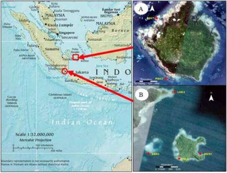
Pongok Island covers an area of about 45 km
2
located
at the middle of the Gaspar Strait. This strait is
strongly influenced by the open water, where the
position at the north is bordered by Karimata Strait
and the southern part is bordered by Java Sea. While
on the west and east is flanked between two islands
which include the Bangka Island and Belitung Island.
In these waters, soft corals were found at both stations,
where each station were coded PGK1 (with position 2°
50'50 .75 "S and 107 °1'44 .58" E), and PGK2 (2 °
53'46 .26 "S and 107 °1'47 .34 "E).
Tegal Island occupies about 1.2 Km
2
. Geographically
that island is located in Lampung Bay, the South
Lampung regency. Tegal island is uninhabited by
humans, but the marine area around the island there
was highly exploited by human activities as; fishing,
aquaculture floating cages and local transport lines. In
this area, there were four stations of soft corals
delineated, where station 1 (MCN1) is located on the
eastern island to the position of 05
0
34'23, 4 "S and
105
0
16 '36.5" E, station 2 (TGL2) located in the south
of the island of 05
0
34'06, 1 "S, and 105
0
16 '51.6 "E,
station 3 (GSN3) in the southwest of the island which
is about 1.2 km to the position of 05
0
34'16, 6"S and
105
0
15' 25.5 "E and station 4 (LHK4) in the northwest
near the island of Small Lahu with position of
05
0
32'37, 3 "S, and 105
0
15 '51.4" E. Water
transparency at each station about 8 meters (Figure 1).
Figure 1 Map of the study site; A) Pongok Island South Bangka;
and B) Tegal Island Lampung Bay
1.2 Sampling Time
The research was conducted in August 2012 in the
Pongok Island waters, South Bangka and September
2012 in Tegal Island waters, Lampung Bay, Indonesia.
1.3 Water Quality measurements
Water quality parameters at each station were
measured
in situ
include: temperature, turbidity,