Basic HTML Version


International Journal of Marine Science 2013, Vol.3, No.34, 267-277
http://ijms.sophiapublisher.com
269
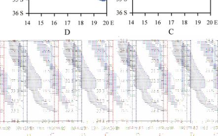
28-36°S, 14-20°E. The three fish species time series
are positively correlated and so their catch is
aggregated to a single index. Lag cross-correlations
are computed between the fish catch index and
parameters averaged July-June in St Helena Bay,
using methods similar to Agenbag et al (2003). One
particular high chlorophyll event (Feb.-Mar. 2008) is
analyzed to understand its forcing, similar to research
methods of Roy et al (2001). Fluctuations in the
pelagic fisheries (Roy et al., 2007) are studied in
greater depth in Jury (2011, 2012).
3 Results
3.1 Coastal climatology
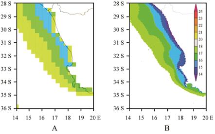
SST climatology maps are compared for CFS and
MODIS in Figure 1a, b. The 30km resolution CFS
product represents the coastal upwelling as a narrow
belt of SST <16
℃
consistent with Lutjeharms and
Meeuwis (1987) and Penven et al (2001), but detached
from the coast in a few places. The 9 km resolution
MODIS validation product exhibits SST <15
℃
that
hug the coast. The CFS warm bias is 1-2
℃
within 30
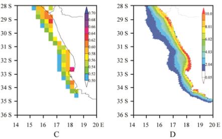
km of the coast. The standard deviation of CFS SST
Figure 1 Mean annual SST a) CFS, b) MODIS and c) CFS SST
standard deviation (
℃
). d) Mean annual MODIS ocean color
(chlorophyll, mg m
-3
)
Note: All mapped at native resolution. Scale in b) applies to a).
CFS data analyzed 1980-2008, MODIS data 1998-2010
(Figure 1c) reveals a narrow band of ~0.6
℃
variance
coinciding with lowest SST that highlights
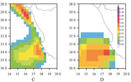
inter-seasonal pulsing. The coastal upwelling creates a
zone of nutrients that feed plankton blooms (Garcia et
al., 2005), as reflected in the MODIS chlorophyll
climatology (Figure 1d). The chlorophyll maximum
(>10 mg m
-3
) is located ~10km seaward of the coast
and coincides with higher SST variance, as outlined in
Romero et al (2002) and Kone et al (2005).
Meridional surface wind maps (averaged 1980-2008)
are compared for CFS and ECMWF in Figure 2a, b.
Both display similarity in the 3 m/s isotach touching
the coast. The area >5 m/s is located northwest of
31°S,16°E in ECMWF, but extends southeast in CFS.
A key difference is in the standard deviations (Figure
2c, d). CFS exhibits a narrow band of >0.3 m/s
variance west of South Africa that reflects the
passage of coastal low pressure cells, while
ECMWF variance is confined southwest of
32°S,18°E in response to synoptic waves of the
circumpolar westerlies. The additional coastal wind
variance (in CFS) is important to upwelling processes
as outlined by Woodson et al (2007).
Figure 2 Mean annual surface meridional wind a) CFS, b)
ECMWF (m/s) and its standard deviation c) CFS, d) ECMWF.
Scales in b) d) apply to a) c) respectively. All analyzed
1980-2008