Basic HTML Version


International Journal of Marine Science 2014, Vol.4, No.22, 197-209
http://ijms.biopublisher.ca
199
are actively involved in the daily life of the subjects,
observe carefully, play various possible roles in
various situations, taking notes on the things that are
considered important and capture images those are
relevant to the research issues. Documents and
literature studies were employed by using historical
critical method; searching documents, archives,
research results, books, various government publications,
and journals which has any relevance to the object of
study (Kartodirdjo, 1992).
The data has been analyzed by using qualitative data
analysis methods, i.e. searching for general statements
about relations between various categories of data
which come into conceptual understanding of reality
based on empirical findings. It is based on thought
that qualitative research data should be analyzed by
arranging data order, organizing into a pattern of
categories and basic description units. Its categorization
are adjusted by formulation of questions which is
proposed in this study and is intended to provide ease
of interpretation, selection, descriptions and
explanations in the analysis form (Patton in Marvasti
2004). Therefore, the analysis stages of qualitative
research includes: (1) comparing the incidence that
matched its category, (2) integrating categories and
their characteristics through comparison between
categories to formulate concept and theory
constructions (3) formulation of conceptual
understanding, (4) writing of the acquired conceptual
understanding (Glaaser & Strauss, 1980). In
qualitative analysis there are three main components,
namely data reduction, data display and conclusion
drawing (Miles & Huberman, 1984), therefore in this
context we used interactive model of analysis as
below (Figure 1).
Figure 1 Interactive model of analysis, Miles & Huberman,
1984
3 Results and Discussion
3.1 Geographical context
Indonesia is often referred to as the world's largest
archipelago, a name which aptly represents its 17.508
(Cribb, 2000), or so islands which span more than
5.000 km (around 3,200 miles) eastward from Sabang
in northern Sumatra to Merauke in Irian Jaya. There
are eight major islands or island groups in this
enormous chain. The largest landmasses consist of
Sumatra, Java, Kalimantan (Borneo), Sulawesi
(Celebes) and West Papua (the western half of Papua
New Guinea), and small islands spread among them.
Indonesian geographical condition poses a pattern of
history, interaction, and cultural acculturation that are
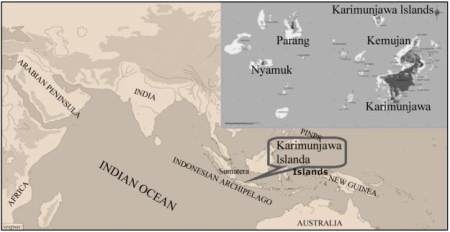
tremendously dynamic. There are Karimunjawa
Islands lying in the middle of the Java Sea as one of
the islands in the Indonesian archipelago (Figure 2).
Figure 2 Position of Karimunjawa Islands in the Indonesian
Archipelago
Astronomically, Karimunjawa Islands are located in
northern, especially in 0°40'39"-5°55'00" latitude and
110°05'57 "-110°31'15". It is bordering and surrounded
by Java Sea. It is required 45 miles or 83 km reached
from Jepara and 60 mil or 110 km from Semarang,
Central Java capital city. It consists of 27 islands, 5
islands of them are inhabited including Karimunjawa,
Parang, Nyamuk, Genting, and Kemujan Island, and
the rest islands are inhabited. It is one of district of
Jepara which has four villages, Karimunjawa village
as capital district, Parang, Nyamuk, and Kemujan.
Parang and Nyamuk has quite difficult access to
another island, it is spent about 7 miles away or three
hours sailing from Karimunjawa capital district.
Before 2011 Nyamuk village initially joined with
Parang but now it has expanded as a new village
(Rochwulaningsih, 2011). It has 110.117,30 ha of
extensive broad area and 7.120 ha of land area