Basic HTML Version


International Journal of Marine Science 2013, Vol.3, No.44, 361-367
http://ijms.sophiapublisher.com
362
information and the best science available (Hiscock, et
al. 2003). However, subsequent progress in this regard
has been slow due to various reasons, including
inadequate scientific infrastructure capable to initiate
or support regulations for sustainable uses. Hence,
scientists and planners shared efforts through the
initiation of long-term monitoring for marine
ecosystem. The aim is to determine the ecological and
socio-economic impact of various management
strategies for the entire coastal line and for the AMPA
as a case study addressing the issue of integration
between science and management. Consequently,
laying a sound foundation for the sustainability of
integrated marine and coastal protected area to be
recognized and respected. This study discussed the
scientific outcomes of research and monitoring (R&M)
on the prevailing environmental condition and its
integration into a comprehensive management
program in Gulf of Aqaba. Collectively, the role of
marine science (R&M) to serve national conservation
issues and resource management for proactive
conservation measures in this region.
1 Material and Methods
A number of related environmental issues and existing
conditions were investigated and analyzed based on
different knowledge resources in Aqaba. Literature,
interviews with various stakeholders and field
measurements on ecological parameters of the marine
environment were implemented aiming at identifying
the pressing marine environmental issues in the
Jordanian coastal area. This includes a foundation of
integrated data management and comprehensive
scientific assessment of coral reef resources and
related processes in the Gulf that are critical to
understanding the ecological actions and reactions
caused by their management decisions. Quantitative
and qualitative analysis of results were made in order
to understand the best practices needed to integrate the
various issues for better utilization of resources and
provision of scientific facts for the coastal habitats of
Aqaba. The Aqaba MPA, which occupies a significant
part of the Jordanian coast with an overall aim of wise
management, can be used as a model of integration
between the resources and marine sciences. Facts and
resources that are discussed in the following
paragraphs represent most of the pressing issues along
the Jordanian coast of the Gulf of Aqaba (Figure 1).
2 Results
2.1 Jordan’s coastal water of the Gulf of Aqaba
Jordan has a single sea outlet of about 27 km on the
Figure 1 Gulf of Aqaba and the Jordanian coast, showing major
human activities
northeastern part of the Red Sea (Figure 1). The Gulf
of Aqaba is a semi-enclosed water basin of about 180
km in length and of about 15 km average width,
connected to the semi-enclosed Red Sea. Surface
water from the Red Sea enters the Gulf of Aqaba
through the Straits of Tiran. Persistent nutrient
depletion occurs because of phytoplankton uptake
along the entire coastal line of Red Sea (Al-Najjar,
2000). Therefore nutrient concentrations of the surface
water in the northern Gulf of Aqaba are very low. In
addition, nutrient inputs from land are generally minor
because of the severe arid conditions prevail in this
area. Accordingly, the phytoplankton productivity and
chlorophyll concentrations are very low (Al-Najjar,
2000) with clean blue water (Figure 2). The ambient
nitrate and phosphate concentrations during summer
stratification (May-September) are less than 0.1 and
0.03 mmol L
-1
, respectively (Badran et al., 2005;
Rasheed et al., 2002). The rich coral reefs in Gulf of
Aqaba are distinctive to these oligotrophic conditions
that rely on filtration from open sea as their main
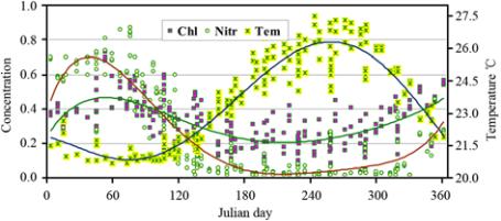
Figure 2 Annual cycle of basic seawater characteristics
temperature "
℃
", nitrate "µ mole L
-1
" and chlorophyll
a
"µ g L
-1
"
in waters of the Gulf of Aqaba, Red Sea (source: marine
environmental appraisal of the Gulf of Aqaba, annual report, 2011)