International Journal of Molecular Evolution and Biodiversity 2016, Vol. 6, No. 1, 1-12
2
invasive species threaten 625 of the threatened species (Bird Life International, 2008). In Ethiopia particularly in
the Afromontane rain forests, habitat destruction and degradation due to anthropogenic activities are reducing the
forest cover and the associated biodiversity (Yeshitila, 2001). Ongoing reductions in bird abundance and species
richness are likely to have far-reaching ecological consequences, with diverse societal impacts ranging from the
spread of disease and loss of agricultural pest control to plant extinctions and trophic cascades (Gaston et al.,
2000).
Dhati Walel is a newly established National Park in Ethiopia with little ecological information. The area is
believed to be rich in faunal diversity (Gonfa et al. 2015). However, there is an accelerated reduction in its faunal
diversity including avian species as a result of man-made pressure and activities, such as uncontrolled hunting,
habitat destruction for agricultural expansion, pressure by domestic animals and heavy encroachment by human
being. Knowledge about avian diversity, distribution and relative abundance is very essential for the
development of sound management plan for a given protected area. However, no research has been carried out to
investigate the diversity, distribution and relative abundance of avian species of Dhati Walel National Park. Thus,
this study was carried out with the objective of gathering baseline information on the diversity, distribution and
relative abundance of the avian fauna of the area.
2 Materials and Methods
2.1 Study area
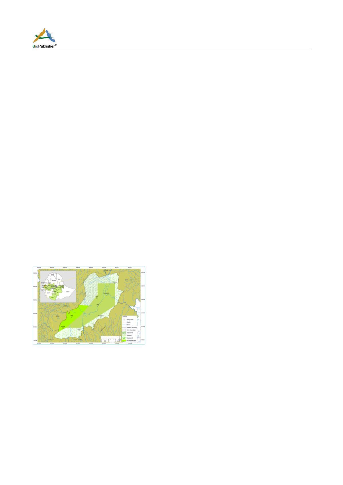
Dhati Walel National Park (established in 2010) is located in western lowlands of Ethiopia, about 647 km from
Addis Ababa, the capital city of Ethiopia (OFWE, 2012). The park lies between the coordinates of 67° 55' 49'' to
72° 45' 03'' E and 10° 05' 25'' to 10° 51' 01''N, covering an area of about 1035 km2 (103,500 ha) (OFWE, 2012).
The elevation in the Park ranges from1390m around Dhati River to 1500m at the peak of mount Walel. There are
four major habitat types: wetland, woodland, riverine forest and grassland. The mean monthly maximum
temperature of the area ranges between 270 C and 290 C and the mean minimum temperature of the area ranges
between150 C and 170 C. The mean annual rainfall of the area is 1 350 mm (Figure 1).
Figure1 Location Dhati Walel National Park and study sites
2.2 Method
Wetland, woodland and riverine forest were surveyed in this particular study. To make the results representative,
20 to 25% of each habitat was assessed as suggested by Bibby et al., (1992). Wetland and woodland habitats were
surveyed using the method of line transects while point count method was used in the riverine forest (Buckland et
al., 2001). For the three blocks of wetland randomly selected (Burka Sabato, Doleti and Dhati), twenty lines
transects, seven line transects each for Burka Sabato and Doleti and six transects for Dhati were laid. For the three
blocks randomly selected from woodland (Bada Toko, Tullu Shimala and Kumbabe), twenty line transects, eight
transects for Bada Toko, nine transects for Tullu Shimala and three line transects for Kumbabe were established.
The length of transects varied based on the size and accessibility of the block sampled. Accordingly, in wetland,
the length of transects was 2 km and in the woodland the length was 1.5 km. Bird species were recorded by
walking at the center of a line transect from both right and left. Line transects were 250-300 m apart to avoid
double counting (Hostler and Martin, 2006) and were placed by random sampling approach in which transect


